 History
White Tank Mountain Regional Park is home to a rich cultural history dating back more than a thousand years. Archaeological evidence shows that at least eleven sites within the park were occupied between A.D. 500 and 1100 by the Hohokam people. These early inhabitants developed communities in the desert, taking advantage of natural resources and seasonal water sources.
Most of these sites are located in large canyons where water was more accessible. Archaeologists have identified village areas ranging from 1 to 75 acres, along with rock shelters and smaller activity sites. Some locations appear to have supported long-term settlements, while others were likely used as temporary camps for hunting and gathering.
Around A.D. 1100, the Hohokam people left the area. Later, during the historic period, the region was inhabited by the Western Yavapai.
Life in the Desert
The White Tanks themselves, natural rock basins that collect and hold water, likely played a key role in attracting and sustaining early communities. These reliable water sources made the surrounding canyons ideal for settlement.
Evidence found throughout the park, including pottery fragments along the Agua Fria and Hassayampa rivers, suggests established travel routes and connections between communities. Archaeologists have also identified features such as agricultural terraces and check dams, indicating that early inhabitants practiced farming by capturing seasonal rainfall and runoff.
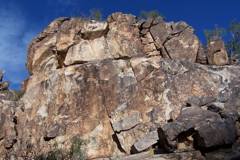
Petroglyphs
The White Tank Mountains are home to hundreds of petroglyphs, images and symbols carefully pecked into rock surfaces by ancient peoples. Some may date back thousands of years.
These petroglyphs are more than artwork, they are meaningful cultural expressions. While their exact meanings are not always known, they are believed to have recorded events, marked important locations, and reflected spiritual or ceremonial beliefs. Some may have served as trail markers or symbolic maps.
Notable viewing areas include:
- Waterfall Canyon Trail (Petroglyph Plaza) – the largest concentration of rock art
- Black Rock Trail – passes through a historic Hohokam village site
- Box Canyon area – additional clusters of petroglyphs near the canyon entrance
Help Protect These Cultural Resources
These irreplaceable cultural sites have endured for centuries—but they remain fragile.
- Do not touch petroglyphs (skin oils can cause damage)
- Do not attempt rubbings or tracings
- Photography is encouraged
- Stay on designated trails
By respecting these sites, you help preserve them for future generations.
White Tank Mountain Regional Park offers not only stunning desert landscapes, but also a meaningful connection to the people who lived here long before us.